Walking Tour - Palmer Burying Grounds
Upper Nyack Historian Winston Perry has assembled an interesting and informative walking tour of the Old Palmer Burying Grounds.
Follow the instructions below. You can find the entrance at 105 Old Mountain Rd. in Upper Nyack.
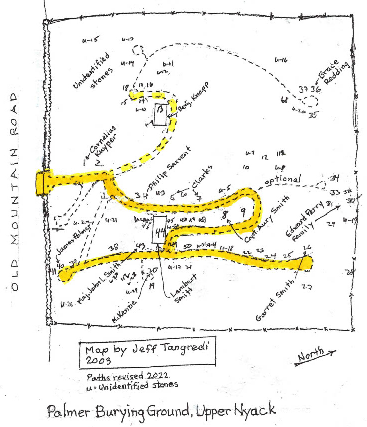
Begin by examining the map and situating yourself at the entrance.
Each part of the tour below is preceeded by a spotlight image that shows the part of the map that is relevant to the tour.
The numbers in square brackets (e.g., [5]) refer to hand-drawn numbers on the map.
Related to this tour, you may also like to explore the digitized version of the extensive document,
"The Old Palmer Burying Grounds, a Photographic Inventory" (opens in new tab/window), presented in 2003 by Jeff Tangredi to
Winston C Perry Jr, who accepted it on behalf of the Village of Upper Nyack.
Winston Perry Message from the Village Historian:
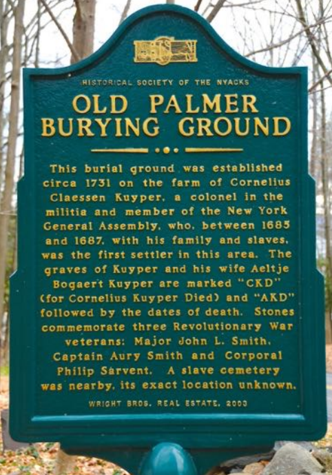
"Welcome to one of the oldest cemeteries in Rockland County.
Please see the historical marker for its story.
Then let's take a walk around to see some of its interesting gravestones.." (continues below)
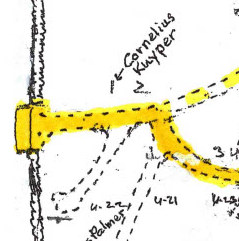
A short distance inside the wall on the left are the graves of the first settlers of Upper Nyack, Cornelius Claussen Kuyper
[1] and
his wife, Aeltje Bogert Kuyper
[2]. Cornelius' stone is marked CKxD MAY Sx1731. The Dis for Died. Aeltje's is marked similarly
with her initials and the date of death. A/D probably stands for Anno Domini. Cornelius inherited all of Upper Nyack and South
Nyack from his father, Claus Jensen van Purmerant, who had already sold most of the future Village of Nyack to Dowe Tallman.
The Kuypers had 11 children at the time of the 1702 census and were slaveowners, holding three people in bondage in 1702.
We don't know where their home was located. Although Cornelius was illiterate and could not sign his name, he became a
justice of the peace, a colonel in the militia (British of course) and a member of the New York Provincial Assembly.
(
see map)
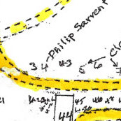
Take the path that angles to the right for a few steps, then turn left to walk in front of the first row of gravestones that you
come to. The first stone on your left is that of Maria (Onderdonk)
[3], the wife of Philip Sarvent. She died at age 73 in
1798 and was matron of the Sarvent family and farm, including 12 years after Philip's death.
(
see map)
The second stone on your left is that of Philip Sarvent
[4] who died in 1786 at age 64. He owned the southernmost farm in Upper Nyack,
including a large quarry near the river that produced red sandstone like his grave stone. Philip was a corporal in the army during
the Revolutionary War. His quarry was the site of skirmishes in 1776 and 1777 in which the Shore Guard militia repelled landing
parties from British ships in search of provisions and military age men. Philip Sarvent's gravestone is recognizable as the work
of Solomon Brewer, a noted stone carver who moved from Springfield, Massachusetts, to the Hudson Valley in 1817 to be near
Nyack's quarries. The stylized face with wings is a soul effigy, a common grave-stone ornament of the period. Brewer's work
can also be seen at the Clarkstown Reformed Church Cemetery in West Nyack.
(
see map)
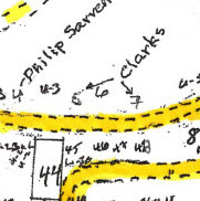
The last three stones in the first row
[5][6][7] are members of the Clark family, also spelled De Clark and De Clerk.
The stones all have tops cut in attractive triple arch shapes. Two of them have curious errors and corrections, indicating
that they may have been amateur letter-carving jobs on stones that had been purchased already shaped. The Town of Clarkstown
was named for members of this family.
(Optional) If you wish, you can continue to the rear of the cemetery to find small white stones hidden in the grass
[29]
through [35] that are the graves of the unfortunate Edward and Maria Perry family. Edward died at age 39, having already
lost seven children as infants.
Make a turn to the right (east) after the Clark family stones to pass in front of the gravestones in the second row.
(
see map)
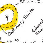
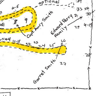
The first stone in the second row is for Nellie Smith
[9], the second wife of Aury Smith. She died in 1844 at age 89.
The next stone is that of Aury Smith
[8], Revolutionary War veteran and owner of the next-to-northernmost farm in Upper
Nyack, extending from and including properties numbered 531 (River House) to 627 (north of Locust Drive). It ran from the
river to the top of the mountain and contained 160 acres. The small house, end to the road behind a stone wall at
627 North Broadway, is believed to have been Aury Smith's farmhouse. He was a captain in the Revolutionary militia
under Colonel Ann Hawkes Hay. Aury's grave is flanked by those of his two wives. The next stone is for Charity Smith
[48] the
first wife of Aury Smith. She died in 1805 at age 67.
(
see map)
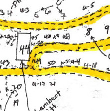
The next three stones are for children of Aury and Charity Smith. They are
Jan [47] (died 1792), Aury [46] (died 1772),
and Lambert [45] (died 1767).
(
see map)
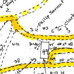
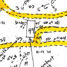
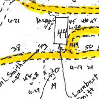
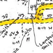
The path is blocked at this point by a large stone lying flat on the ground
[44]. Because of its size this was probably
its intended position. It commemorates Lambert Smith (died 1764), his wife Hanne (died 1760), and their children John,
Genne, Teunis and Marget. Lambert and Hanne were also the parents of Major John Smith and Captain Aury Smith, who have
separate graves nearby. Lambert owned nearly half of Upper Nyack. His farm extended from and included what is now
Number 531, River House, to Hook Mountain, and included 320 acres. It was divided between sons John and Aury upon Lambert's death.
(
see map)
Since the path is blocked at this point, turn left between two stones to reach the path in front of the third row of stones.
We suggest you walk toward the rear of the cemetery and view the stones in this row on your return. They begin with Garret
Smith
[26] (died 1837), George Polhemus
[25] (died 1857), James Ausker Smith
[24] (died 1834). Aaron Smith
[23] (died 1844),
and John Smith
[22] (died 1832). After several smaller foot stones, the next standing stone is that of Catharine
Myers
[50] (died 1840), the wife of Abraham Myers. The next stone is that of Gitty Smith
[50], who died in 1817 at age 21.
(
see map)
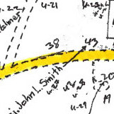
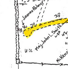
You will pass the end of the large Lambert Smith stone mentioned above and come to the stone of Major John L. Smith
[43].
He was a Revolutionary War veteran and owner of the northernmost farm in Upper Nyack, extending from and including the
Haring-Cason Preserve to Hook Mountain. Major Smith had a riverfront house, the site of which is visible from Nyack
Beach State Park, looking a short distance to the south. Smith's stone house was shelled and burned out by the British,
then rebuilt, and finally found to be too fragile to repair in the 1970s. The north wing of the present house
replicates its location and dimensions.
(
see map)
The next stone is for John Smith
[38], son of George and Elizabeth, who died in 1802, aged 8 months.
(
see map)
The last stone in the third row, next to the front wall of the cemetery is that of James Palmer
[40], who died in 1775.
The Old Palmer Burying Ground was deeded to a board of 24 people by a later James Palmer, perhaps a son, in 1837.
(
see map)
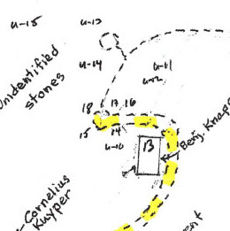
Having visited all the gravestones that are in recognizable rows, you can now visit the remaining gravestones that are located more randomly.
(see map)
The grave of Donald McKenzie
[20] (died 1798) is located on the east side of the path just traveled. A second large
stone with face up
[13] is located a little to the northwest of the cemetery entrance. It is for Benjamin Knapp,
Sener (sic), who owned a very large farm extending from what is now School Street to Old Mountain Road, until his death
in 1762. It was owned by his grandsons at the time of the Revolutionary War.
(
see map)
Just to the west of the Benjamin Knapp stone are the stones of Catharine
[18] (died 1803), wife of William Palmer,
and those of Henry Palmer
[17] (died 1805), and his wife Hannah Knapp Palmer
[16](died 1833). Henry is said to have
been in the shipping business in New York City where he refused to do business with the British during their
occupation and came to Nyack to escape retribution. He married a Knapp and bought part of the Knapp farm, including
this burying ground.
(
see map)
Just west of Benjamin Knapp's stone in the southwest corner of the burying ground are many small unmarked stones in no
recognizable rows. It is possible that this is the burying ground for slaves mentioned in history books as being a
short distance up the hill. Or it may just be where unwanted stones were tossed. Census records show that some of
the early Upper Nyack residents who are buried in this burying ground were slave owners. Future research may discover
where African immigrants held in bondage were buried.
(see map)
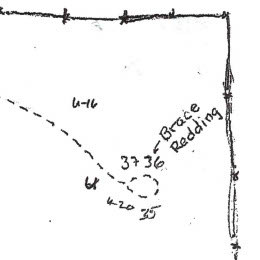
In the far northwest corner of the cemetery are the gravestones of Brace Redding
[36] (died 1850), and his wife Rebecca
[37] (died 1853).
Brace was a ship carpenter, and his house, built in 1834, is still standing at 9 Van Houten Street, Upper Nyack.
(
see map)
Tour credits
here.
